 Rylee88:
I need help
Rylee88:
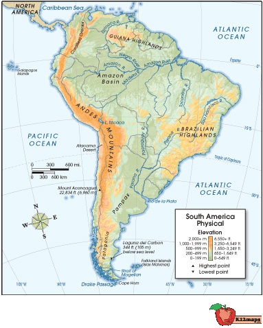
Analyze the purposes of map projections (political, physical, special purpose) and explain the applications of various types of maps. Use the map below to answer the following question: Physical map of South America, with longitude and latitude lines spanning from 100 W longitude to 15 W longitude, and 45 S latitude to 15 N latitude. Orange coloration shows Andes Mountains to the west, and Brazilian Highlands to the east, as well as Guiana Highlands to the north. Amazon River Basin is shown, as well as clear views of the Pacific and Atlantic Oceans to the west and east, respectively. © 2012 The Exploration Company What feature does this map have that is not specific to physical maps? elevation latitude lines landforms rivers
 XxXNessalulbaddieXxX:
i gotthuu
XxXNessalulbaddieXxX:
u got a screen shot or thats it ?
 Rylee88:
Thats it
XxXNessalulbaddieXxX:
ight so like i thought this was ss
XxXNessalulbaddieXxX:
social studies
Rylee88:
o
XxXNessalulbaddieXxX:
XxXNessalulbaddieXxX:
or i might be wrong
Rylee88:
OMG I PUT THIS ON MATH XD ITS HISTORY
XxXNessalulbaddieXxX:
but longutide and crap is social studies i believe
Rylee88:
Pfffft Lemme make another one
XxXNessalulbaddieXxX:
:
XxXNessalulbaddieXxX:
ight jit xd
Join our real-time social learning platform and learn together with your friends!
 Twaylor:
Time flies doesn't it? I tried to not be the second squeaky wheel of the household and ended up hurting myself and others severely.
Twaylor:
Time flies doesn't it? I tried to not be the second squeaky wheel of the household and ended up hurting myself and others severely.
 clllaaaaaire:
any tips? the quality isn't the best because I am using this site on my computer
clllaaaaaire:
any tips? the quality isn't the best because I am using this site on my computer
 Midnight97:
Kinda a roleplay story between me and my friend enjoy... Part one Forgive me for all the screenshots.
Midnight97:
Kinda a roleplay story between me and my friend enjoy... Part one Forgive me for all the screenshots.
 StevenisGhost:
what type of song should I make next, and will y'all go check out my new song on
Midnight97:
My drawing sure changed over the years look at these two pictures from 2024 to no
StevenisGhost:
what type of song should I make next, and will y'all go check out my new song on
Midnight97:
My drawing sure changed over the years look at these two pictures from 2024 to no
 EdwinJsHispanic:
"poem" love is So Beautiful to have. But it's so hard to have. At this point I don't know whether its worth the wait Or if it's just millions of miles to re
EdwinJsHispanic:
"poem" love is So Beautiful to have. But it's so hard to have. At this point I don't know whether its worth the wait Or if it's just millions of miles to re
EdwinJsHispanic:
"poem" love is So Beautiful to have. But it's so hard to have. At this point I don't know whether its worth the wait Or if it's just millions of miles to re
EdwinJsHispanic:
"poem" love is So Beautiful to have. But it's so hard to have. At this point I don't know whether its worth the wait Or if it's just millions of miles to re
 Breathless:
I don't know if this would be considered art, but its close enough I believe, Any
Breathless:
I don't know if this would be considered art, but its close enough I believe, Any