 strugglinginSchool27:
I need help with this Assignment. I will post the photo in the comment section.
 Markthegoat1117:
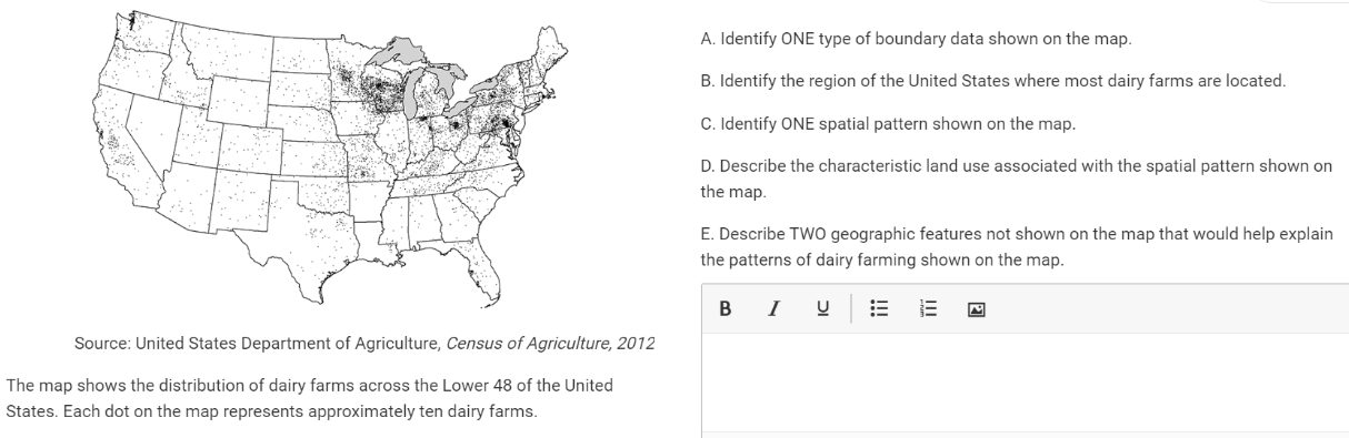
A. One type of boundary data shown on the map could be state boundaries. B. The region of the United States where most dairy farms are located is the Midwest region, specifically in states like Wisconsin, Minnesota, and Iowa. C. One spatial pattern shown on the map could be clustering, where dairy farms are concentrated in specific areas rather than evenly distributed across the country. D. The characteristic land use associated with the spatial pattern shown on the map is agricultural land use, specifically for dairy farming. E. Two geographic features not shown on the map that would help explain the patterns of dairy farming shown on the map could be proximity to water sources (such as rivers or lakes) for irrigation and access to transportation networks (such as highways or railroads) for distribution of dairy products.
 MarioMx64:
A
Markthegoat1117:
MarioMx64:
your right. sorry
Markthegoat1117:
 snowie:
@mariomx64
snowie:
"It's a me Mario wa hoo"
 Treeko:
A
snowie:
A
Join our real-time social learning platform and learn together with your friends!
 Twaylor:
Time flies doesn't it? I tried to not be the second squeaky wheel of the household and ended up hurting myself and others severely.
Twaylor:
Time flies doesn't it? I tried to not be the second squeaky wheel of the household and ended up hurting myself and others severely.
 clllaaaaaire:
any tips? the quality isn't the best because I am using this site on my computer
clllaaaaaire:
any tips? the quality isn't the best because I am using this site on my computer
 Midnight97:
Kinda a roleplay story between me and my friend enjoy... Part one Forgive me for all the screenshots.
Midnight97:
Kinda a roleplay story between me and my friend enjoy... Part one Forgive me for all the screenshots.
 StevenisGhost:
what type of song should I make next, and will y'all go check out my new song on
Midnight97:
My drawing sure changed over the years look at these two pictures from 2024 to no
StevenisGhost:
what type of song should I make next, and will y'all go check out my new song on
Midnight97:
My drawing sure changed over the years look at these two pictures from 2024 to no
 EdwinJsHispanic:
"poem" love is So Beautiful to have. But it's so hard to have. At this point I don't know whether its worth the wait Or if it's just millions of miles to re
EdwinJsHispanic:
"poem" love is So Beautiful to have. But it's so hard to have. At this point I don't know whether its worth the wait Or if it's just millions of miles to re
EdwinJsHispanic:
"poem" love is So Beautiful to have. But it's so hard to have. At this point I don't know whether its worth the wait Or if it's just millions of miles to re
EdwinJsHispanic:
"poem" love is So Beautiful to have. But it's so hard to have. At this point I don't know whether its worth the wait Or if it's just millions of miles to re
 Breathless:
I don't know if this would be considered art, but its close enough I believe, Any
Breathless:
I don't know if this would be considered art, but its close enough I believe, Any