 Khalia:
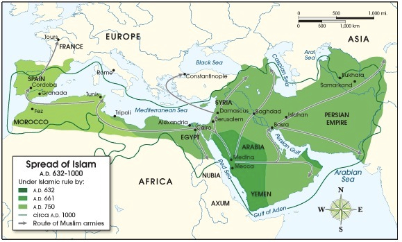
The following map shows the spread of Islam from 632 A.D. (CE) to 1000 A.D. (CE). Use the map to answer the following question: A map showing the spread of Islam from 632 A.D. (CE) to 1000 A.D. (CE). The spread of Islam during this period extended to include the northern coast of Africa, Morocco, Egypt, the Arabian Peninsula, the Persian Empire, Syria, and Spain. Large bodies of water shown on the map include the Mediterranean Sea (bordering northern Africa), the Red Seas (bordering the eastern coast of the Arabian Peninsula), the gulf of Aden (bordering the southern coast of the Arabian Peninsula), the Arabian Sea (bordering the southeastern coast of the Arabian Peninsula), Caspian Sea (north of the Persian Empire), and the Black Sea (north of Syria). © 2012 The Exploration Company What does this map indicate about the Crusades? The Crusades were a direct result of Muslim conquest of Jerusalem. Much of the Holy Land had been under Muslim control for centuries before the Crusades began. The Crusades were a direct result of Muslim invasion of Tours. Land bordering the Mediterranean Sea was not a concern for Crusaders.

 Gdeinward:
What do you feel is the answer?
Join our real-time social learning platform and learn together with your friends!
 Bounty:
the world keeps moving fast and I'm stuck in a time lapse all I need is a minute
Bounty:
can I get so tips on how to start my journey into semi-realism art also on how to
Bounty:
the world keeps moving fast and I'm stuck in a time lapse all I need is a minute
Bounty:
can I get so tips on how to start my journey into semi-realism art also on how to
 Strawberryluna:
Read my poem. Im not for criticism its a poem I wrote after my breakup: Youu2019ll never understand the way you made me break, I hate that I still love you
Bounty:
first poem in a min- (tittle)? one moment i'm fine I smile till my face burns I laugh till I cant breath Then I cry I wonder where I went wrong I listen to
Strawberryluna:
Read my poem. Im not for criticism its a poem I wrote after my breakup: Youu2019ll never understand the way you made me break, I hate that I still love you
Bounty:
first poem in a min- (tittle)? one moment i'm fine I smile till my face burns I laugh till I cant breath Then I cry I wonder where I went wrong I listen to
 Twaylor:
3d printing a glider (for 150 pound 5'8 person - prolly should make it for up to
Twaylor:
3d printing a glider (for 150 pound 5'8 person - prolly should make it for up to
 cullenn:
pitter patter sound of rain gently tapping my window tonight. calming, soothing, right? not for me.
cullenn:
pitter patter sound of rain gently tapping my window tonight. calming, soothing, right? not for me.

 Arriyanalol:
DON'T BUY TICKETS TO SEAWORLD i watched a documentary on seaworld and its sad wha
Arriyanalol:
DON'T BUY TICKETS TO SEAWORLD i watched a documentary on seaworld and its sad wha
 natalieee:
who else wants a job in biology? I love biomedical science and want to work with
natalieee:
who else wants a job in biology? I love biomedical science and want to work with