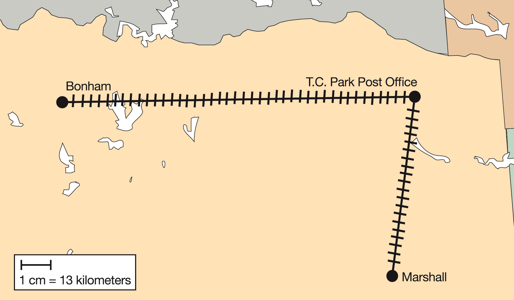
This picture shows the railroads in Texas in 1900. If a passenger wanted to travel from Bonham to Marshall, he would have to go to T.C. Park Post Office and then to Marshall. On the map, the distance from Bonham to T. C. Park Post office is 11.5 cm and the distance from T. C. Park Post Office to Marshall is 6 cm. On the the map 1cm = 13 km. Although we could measure the displacement if we had a map to scale, why can we not calculate it?
 MiraAngel:
Do you have the picture?
MiraAngel:
@Vocaloid
 MiraAngel:
thx
Thank u
Do I want the possible answers to
MiraAngel:
yes please
MiraAngel:
@ dude
MiraAngel:
@Ultrilliam
MiraAngel:
@MrMudd183
MiraAngel:
I tagged some people who may be able to help! :)
Ok thank u
@undeaddragon26
 JAIDENGYMNASTIC:
uhhh hmm
JAIDENGYMNASTIC:
i know this hold on
Idk this guy right there had the same question 2 years ago
Did u want the Multiple choice answers
JAIDENGYMNASTIC:
yes plz
The post office no longer exists. Displacement between the two cities is not a straight line. The scale shown on the map is wrong. We don't know the angle between the rail lines.
JAIDENGYMNASTIC:
OHHH AND WELCOME TO QUESTION COVE OR QC
Thank u😀
Nice to meet u
JAIDENGYMNASTIC:
NOW basicly if you need ANYTHING OR YOU CAN JUST CHAT WITH PEOPLE YOU CAN ALWAYS COME TO ME
JAIDENGYMNASTIC:
YOU TOO
JAIDENGYMNASTIC:
srry i always do caps when talking to new peeps lol
Thank u every much☺️
JAIDENGYMNASTIC:
np
 Ashley29:
Welcome to Question cove lol
Hiiiiiii
Ashley29:
Hi
just trying to finish up some questions I had a hard time trying to figure out
thank you guys for making me feel welcOme
JAIDENGYMNASTIC:
np
Ashley29:
Yeep
So u said it was between those to questions.
MiraAngel:
Did you get the answer to your question? @Dudes11
No lol I was answer other questions and gonna go back to it
MiraAngel:
lol oh okay
Add the four questions which one should I try
Outta*
Out of the four answers which one should I try****
@miraAngel
MiraAngel:
I would go with the 4th
MiraAngel:
it's either the 2nd or 4th. But I would choose the 4th.
Join our real-time social learning platform and learn together with your friends!
 Bounty:
the world keeps moving fast and I'm stuck in a time lapse all I need is a minute
Bounty:
can I get so tips on how to start my journey into semi-realism art also on how to
Bounty:
the world keeps moving fast and I'm stuck in a time lapse all I need is a minute
Bounty:
can I get so tips on how to start my journey into semi-realism art also on how to
 Strawberryluna:
Read my poem. Im not for criticism its a poem I wrote after my breakup: Youu2019ll never understand the way you made me break, I hate that I still love you
Bounty:
first poem in a min- (tittle)? one moment i'm fine I smile till my face burns I laugh till I cant breath Then I cry I wonder where I went wrong I listen to
Strawberryluna:
Read my poem. Im not for criticism its a poem I wrote after my breakup: Youu2019ll never understand the way you made me break, I hate that I still love you
Bounty:
first poem in a min- (tittle)? one moment i'm fine I smile till my face burns I laugh till I cant breath Then I cry I wonder where I went wrong I listen to
 Twaylor:
3d printing a glider (for 150 pound 5'8 person - prolly should make it for up to
Twaylor:
3d printing a glider (for 150 pound 5'8 person - prolly should make it for up to
 cullenn:
pitter patter sound of rain gently tapping my window tonight. calming, soothing, right? not for me.
cullenn:
pitter patter sound of rain gently tapping my window tonight. calming, soothing, right? not for me.

 Arriyanalol:
DON'T BUY TICKETS TO SEAWORLD i watched a documentary on seaworld and its sad wha
Arriyanalol:
DON'T BUY TICKETS TO SEAWORLD i watched a documentary on seaworld and its sad wha
 natalieee:
who else wants a job in biology? I love biomedical science and want to work with
natalieee:
who else wants a job in biology? I love biomedical science and want to work with