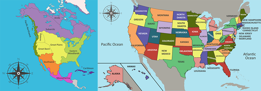
Compare maps of the world in ancient times with current political maps. Use the maps below to answer the following question. Image of two maps side by side. The map on the left shows a map of North America showing different cultural regions. In the south there is Mesoamerica. Above Mesoamerica is the Southwest. Along the Pacific Coast is the Pacific Northwest. Beside the Pacific Northwest and in the center of what is now the United States there is the Great Plains, Great Basin, and Plateau. On the eastern side of the continent is the Eastern Woodlands. In the North, there is the Subarctic and the Arctic. The map on the right shows a topographic map of the Unite States showing hills, mountains, grasslands, and wetlands. Public Domain According to these maps, the Southwest Native American cultural region was located in the United States and what other North American country?
You'll need to post the diagrams
i need to post them
ummmm in not sure how i do that
im
 Laylalyssa:
To post a diagram you can SS it and then send it in here, like copy paste
there
okay so mexico
correct
ok thanks
no problem
Join our real-time social learning platform and learn together with your friends!
 Twaylor:
Time flies doesn't it? I tried to not be the second squeaky wheel of the household and ended up hurting myself and others severely.
Twaylor:
Time flies doesn't it? I tried to not be the second squeaky wheel of the household and ended up hurting myself and others severely.
 clllaaaaaire:
any tips? the quality isn't the best because I am using this site on my computer
clllaaaaaire:
any tips? the quality isn't the best because I am using this site on my computer
 Midnight97:
Kinda a roleplay story between me and my friend enjoy... Part one Forgive me for all the screenshots.
Midnight97:
Kinda a roleplay story between me and my friend enjoy... Part one Forgive me for all the screenshots.
 StevenisGhost:
what type of song should I make next, and will y'all go check out my new song on
Midnight97:
My drawing sure changed over the years look at these two pictures from 2024 to no
StevenisGhost:
what type of song should I make next, and will y'all go check out my new song on
Midnight97:
My drawing sure changed over the years look at these two pictures from 2024 to no
 EdwinJsHispanic:
"poem" love is So Beautiful to have. But it's so hard to have. At this point I don't know whether its worth the wait Or if it's just millions of miles to re
EdwinJsHispanic:
"poem" love is So Beautiful to have. But it's so hard to have. At this point I don't know whether its worth the wait Or if it's just millions of miles to re
EdwinJsHispanic:
"poem" love is So Beautiful to have. But it's so hard to have. At this point I don't know whether its worth the wait Or if it's just millions of miles to re
EdwinJsHispanic:
"poem" love is So Beautiful to have. But it's so hard to have. At this point I don't know whether its worth the wait Or if it's just millions of miles to re
 Breathless:
I don't know if this would be considered art, but its close enough I believe, Any
Breathless:
I don't know if this would be considered art, but its close enough I believe, Any