 L2doll:
Rllyty image


 ThisGirlPretty:
hihi, what is this for?
L2doll:
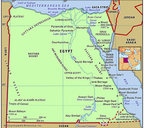
Describe ONE example of each of the following spatial concepts in the map above: Location Place Pattern
L2doll:
I already have a solid answer
L2doll:
Heres the answer i came up with
L2doll:
An example of the spatial location of concept could be saying that Cairo is about 500 miles south of the Mediterranean Sea. This would be relative location. An example of pattern is that most of the cities fall along the coastline or near it, most likely because it is a source of food and transportation.
L2doll:
AND then heres is the other one
L2doll:
C. Identify the scale used on the map above.
L2doll:
THat one I'm not too sure
 QuestionCoveBot:
Okay, so for the examples, they seem good, and it fits.
QuestionCoveBot:
Then for the scale, I assume it would have to be done any readable way. So, Cairo is about 100 miles south of the Mediterranean. (Had to look that up.) But Egypt (according to Google) is 1k+ north to south. So scale wise, you coulf really do many options.
QuestionCoveBot:
*could And those options would be by 100 miles, 150, 200, or 50 if you really like.
QuestionCoveBot:
But if we are talking scale is with another country or US state, would be Alaska which is slightly bigger than Egypt.
Join our real-time social learning platform and learn together with your friends!
 natalieee:
who else wants a job in biology? I love biomedical science and want to work with
natalieee:
who else wants a job in biology? I love biomedical science and want to work with
 Twaylor:
Time flies doesn't it? I tried to not be the second squeaky wheel of the household and ended up hurting myself and others severely.
Twaylor:
Time flies doesn't it? I tried to not be the second squeaky wheel of the household and ended up hurting myself and others severely.
 clllaaaaaire:
any tips? the quality isn't the best because I am using this site on my computer
clllaaaaaire:
any tips? the quality isn't the best because I am using this site on my computer
 Midnight97:
Kinda a roleplay story between me and my friend enjoy... Part one Forgive me for all the screenshots.
Midnight97:
Kinda a roleplay story between me and my friend enjoy... Part one Forgive me for all the screenshots.
 StevenisGhost:
what type of song should I make next, and will y'all go check out my new song on
Midnight97:
My drawing sure changed over the years look at these two pictures from 2024 to no
StevenisGhost:
what type of song should I make next, and will y'all go check out my new song on
Midnight97:
My drawing sure changed over the years look at these two pictures from 2024 to no
 EdwinJsHispanic:
"poem" love is So Beautiful to have. But it's so hard to have. At this point I don't know whether its worth the wait Or if it's just millions of miles to re
EdwinJsHispanic:
"poem" love is So Beautiful to have. But it's so hard to have. At this point I don't know whether its worth the wait Or if it's just millions of miles to re
EdwinJsHispanic:
"poem" love is So Beautiful to have. But it's so hard to have. At this point I don't know whether its worth the wait Or if it's just millions of miles to re
EdwinJsHispanic:
"poem" love is So Beautiful to have. But it's so hard to have. At this point I don't know whether its worth the wait Or if it's just millions of miles to re