 Arieonna:
please help more history 1/5
 ChloeHamilton:
Normally on a physical map, it won't show buildings or populations. so, hopefully, that narrows it down for you
 SaltTheLoser:
I’d go with political lines
SaltTheLoser:
Actually that’s wrong
SaltTheLoser:
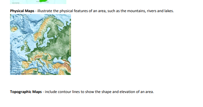
Physical Maps - illustrate the physical features of an area, such as the mountains, rivers and lakes. Topographic Maps - include contour lines to show the shape and elevation of an area.
 DeadOfWinter:
Let's eliminate out Population Because this is not a common feature of a physical map.
DeadOfWinter:
So now, we have "A", "B", And "D" Left over.
DeadOfWinter:
Also breaking it down even more. A physical map also represents the Earth's various natural features, such as mountains, water bodies, and deserts.. etc
DeadOfWinter:
@questioncovebot
DeadOfWinter:
Let's exit out Buildings as well because there's nothing in the definition for "Physical maps" that doesn't say anything about buildings.
DeadOfWinter:
Now, what we have left over is Political borders. And Elevation Key.
DeadOfWinter:
Your final answer would be. "B"
DeadOfWinter:
Thus, there's no elevation in Physical maps. But in topographic maps, it is.
DeadOfWinter:
"B" Would be correct because it is used for Political borders and etc. "Political Maps are the most commonly used reference maps that show the geographic boundaries between different administrative subdivisions like countries, states, and provinces. Depending on their use, some political maps also show principal roads, cities, towns, and districts. "
Arieonna:
it was D
DeadOfWinter:
I'm sorry, it doesn't say.
Join our real-time social learning platform and learn together with your friends!
 natalieee:
who else wants a job in biology? I love biomedical science and want to work with
natalieee:
who else wants a job in biology? I love biomedical science and want to work with
 Twaylor:
Time flies doesn't it? I tried to not be the second squeaky wheel of the household and ended up hurting myself and others severely.
Twaylor:
Time flies doesn't it? I tried to not be the second squeaky wheel of the household and ended up hurting myself and others severely.
 clllaaaaaire:
any tips? the quality isn't the best because I am using this site on my computer
clllaaaaaire:
any tips? the quality isn't the best because I am using this site on my computer
 Midnight97:
Kinda a roleplay story between me and my friend enjoy... Part one Forgive me for all the screenshots.
Midnight97:
Kinda a roleplay story between me and my friend enjoy... Part one Forgive me for all the screenshots.
 StevenisGhost:
what type of song should I make next, and will y'all go check out my new song on
Midnight97:
My drawing sure changed over the years look at these two pictures from 2024 to no
StevenisGhost:
what type of song should I make next, and will y'all go check out my new song on
Midnight97:
My drawing sure changed over the years look at these two pictures from 2024 to no
 EdwinJsHispanic:
"poem" love is So Beautiful to have. But it's so hard to have. At this point I don't know whether its worth the wait Or if it's just millions of miles to re
EdwinJsHispanic:
"poem" love is So Beautiful to have. But it's so hard to have. At this point I don't know whether its worth the wait Or if it's just millions of miles to re
EdwinJsHispanic:
"poem" love is So Beautiful to have. But it's so hard to have. At this point I don't know whether its worth the wait Or if it's just millions of miles to re
EdwinJsHispanic:
"poem" love is So Beautiful to have. But it's so hard to have. At this point I don't know whether its worth the wait Or if it's just millions of miles to re