 bill533:
The amount of land that is considered to be _________ has not changed significantly over the century. A) grassland B) woody wetlands C) mangrove swamp D) evergreen forests
bill533:
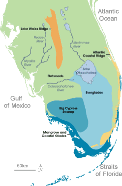
Land Before Time: Man’s Influence on a Local Climate Patty Gordon Florida: Over the millennia, rising and receding seas have exposed and covered much what we today call Florida. Glaciers came and went, polar ice caps melted, waters rose, and a series of ridges stood as islands in a vast ocean that covered most of Florida. During the last glacial stage, approximately 20,000 years ago, the peninsula's land mass was nearly doubled. This connected Florida to the American southwest and narrowed the Gulf of Mexico. Conditions throughout Florida during this time were drier, allowing arid plants and animals to survive. Today, seas have risen to current levels and most of Florida is humid and subtropical. A cool dry season gives way to a warm rainy season. Tropical storms and hurricanes form in the Gulf and Atlantic and sweep across the peninsula. The average annual rainfall totals 50 inches. Occasional freezing temperatures prevent the establishment of tropical plants and have moved citrus growers farther south. However, the typical winter temperatures average 50 degrees Fahrenheit, with mostly sunny skies. The natural landscape of southern Florida was once dominated by wetlands. Rainfall in central Florida feeds the Kissimmee River, which flows into Lake Okeechobee. The southern end of Lake Okeechobee spills into the Everglades, which join with coastal mangrove forests. Today's water flow has been dramatically reduced, and the Everglades are only about half the size they once were. From swampy forests dominated by giant cypress trees, to bogs and marshes, to the tree-island-dotted Everglades, almost every ecosystem in Florida was and is under the direct influence of water.
 bill533:
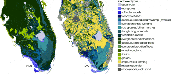
Water and Weather The changes in the Everglades and available water have had profound ecological consequences, but could the change in the free-flowing water into the agricultural and urban lands have also changed the weather? Between 1997 and 2001, Florida suffered five consecutive summers of extreme drought. In January 1997 an unexpected freeze caught Florida farmers off guard, causing the near-total loss of winter crops in the cultivated areas south of Lake Okeechobee. In 2004, the state was soaked from four hurricanes. The increased public perception that droughts and freezes in Florida were becoming more frequent and severe focused researchers on the question of whether land cover might have had something to do with the recent meteorological changes. Roger Pielke and Curtis Marshall, a meteorologist from the NOAA National Centers for Environmental Prediction, together with Lou Steyaert and Deb Willard S. of the U. Geological Survey, utilized a modeling system called the Regional Atmospheric Modeling System, or RAMS, to create and analyze two land cover data sets, a present-day set and a historical set. The RAMS model works by extrapolating nature’s daily cycle, [the sun comes up in the morning and begins heating the Earth.] The incoming solar energy is partitioned in one of three ways: some evaporates water, some heats the land surface, which in turn heats the air, and some is conducted down into the soil. It is land cover that determines which of these three things happens. RAMS performs all the mathematical calculations to determine the net result of all the different energy-balance characteristics of all the different land cover types, and then predicts what the effect on the weather would be. The team used modern land cover maps from satellite data collected in the early 1990s by the Thematic Mapper sensor on NASA’s Landsat 5 satellite to develop composite reference images of the present conditions in Florida.
 bill533:
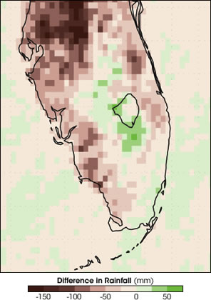
To test how land cover change might have influenced summer climate, the research team used the RAMS model to create pairs of climate simulations for three July-August periods: 1973, 1989, and 1994. The 1973 and 1994 seasons were wetter than normal, while 1989 was an unusually dry year. For all three periods, the team discovered significant differences in the intensity and location of precipitation when the pre-1900 land cover was replaced with the present-day land cover. Brown areas are areas that are now drier while wetter areas are green. Averaged across the entire state, precipitation was predicted to be 12% less than it would have been if Florida’s pre-1900 landscape still existed. Research Image II – Difference in Rainfall
 bill533:
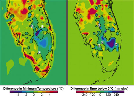
Temperatures throughout Florida were affected as well. Urbanization seemed to increase maximum daily temperatures by several degrees, particularly around the Miami-Ft. Lauderdale area in the southeast. In the center of the state, the daily temperature differences were amplified, with current daytime high temperatures up to four degrees Celsius warmer and nighttime lows up to 4 degrees cooler.
 bill533:
The team reviewed the historical record of severe freeze impacts on the Florida citrus industry. Using pre-1900 and present-day land cover data, they created a series of paired comparisons of the modeled weather at the time of three damaging freezes: December 26, 1983, December 25, 1989, and January 19, 1997. According to their model results, the southward creep of the winter freeze line appeared to be the direct result of moving the farms farther south. The model indicated that areas where wetlands had been converted to agriculture experienced nighttime temperatures that were as much as 2 degrees Celsius colder than they would have been in the past. Two degrees can be the difference between a light freeze and devastating one. In all three cases, not only were the temperatures colder in the converted areas, but they stayed below zero for longer periods. The researchers concluded that their research shows that the land itself exerts a primary influence on the climate we experience. And it is human interaction with that land that is impacting local climate change.
bill533:
@cathrinerose23
 cathrinerose23:
yurr
bill533:
i know but look at the pictures than the passage
cathrinerose23:
so watchu need
bill533:
The amount of land that is considered to be _________ has not changed significantly over the century. A) grassland B) woody wetlands C) mangrove swamp D) evergreen forests
bill533:
The greatest increase in rainfall can be seen in the area of A) Lake Okeechobee. B) the Gulf of Mexico. C) the Atlantic Ocean. D) the far southeast tip.
Join our real-time social learning platform and learn together with your friends!
 Bounty:
the world keeps moving fast and I'm stuck in a time lapse all I need is a minute
Bounty:
can I get so tips on how to start my journey into semi-realism art also on how to
Bounty:
the world keeps moving fast and I'm stuck in a time lapse all I need is a minute
Bounty:
can I get so tips on how to start my journey into semi-realism art also on how to
 Strawberryluna:
Read my poem. Im not for criticism its a poem I wrote after my breakup: Youu2019ll never understand the way you made me break, I hate that I still love you
Bounty:
first poem in a min- (tittle)? one moment i'm fine I smile till my face burns I laugh till I cant breath Then I cry I wonder where I went wrong I listen to
Strawberryluna:
Read my poem. Im not for criticism its a poem I wrote after my breakup: Youu2019ll never understand the way you made me break, I hate that I still love you
Bounty:
first poem in a min- (tittle)? one moment i'm fine I smile till my face burns I laugh till I cant breath Then I cry I wonder where I went wrong I listen to
 Twaylor:
3d printing a glider (for 150 pound 5'8 person - prolly should make it for up to
Twaylor:
3d printing a glider (for 150 pound 5'8 person - prolly should make it for up to
 cullenn:
pitter patter sound of rain gently tapping my window tonight. calming, soothing, right? not for me.
cullenn:
pitter patter sound of rain gently tapping my window tonight. calming, soothing, right? not for me.

 Arriyanalol:
DON'T BUY TICKETS TO SEAWORLD i watched a documentary on seaworld and its sad wha
Arriyanalol:
DON'T BUY TICKETS TO SEAWORLD i watched a documentary on seaworld and its sad wha
 natalieee:
who else wants a job in biology? I love biomedical science and want to work with
natalieee:
who else wants a job in biology? I love biomedical science and want to work with